

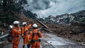
After a flood, roads are cut, terrain reshaped, comms down—rescue teams face a disaster zone of information vacuum.
Which sectors still hold survivors? Which routes remain passable? Where are the collapsed structures? All triangulated by experience and manpower, point by point. Every major flood exposes the same gap: rescue needs a real-time, precise digital base map of the disaster site—and it needs it now.
But getting that map with minimal crew and minimum time, off-grid—existing workflows can’t deliver. The Hunter Wing Man-Portable UAV Mapping & Recognition System is built exactly for this gap.
Not Just Aircraft—Weight Is the Point
Post-disaster recon means wading through mud and standing water. Every extra kilogram costs efficiency. The Hunter Wing core AI computing module + power unit weigh under 600 g—roughly 1/5 of conventional stacks.
One person carries the kit into complex terrain. One flight covers 2–5 km² of search area, depending on airframe.
Real-Time Mapping, Even Offline
Comms collapse at scale after disaster. Conventional workflows fly first, process later offline—decision cycles stretch to hours.
Hunter Wing runs fully offline, man-portable. Orthophotos and 3D models are generated in sync with the flight—data is ready the moment the mission ends. No waiting for RTH, no reliance on downlink.
From Aerial Capture to Detection—0.5 Seconds
Mapping answers “what does the site look like”; SAR asks “where are the people”.
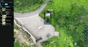
Hunter Wing packs multi-class object detection—person and vehicle recognition in ≤0.5 s, with auto-count and lat/lon positioning.
Detections are bound to sub-meter coordinates and pinned on the orthophoto—SAR teams move straight to the spot.
First Flight in 10 Minutes, Out of the Box
Deep compatibility with DJI Enterprise airframes (M400 RTK, M4E, M350, etc.)—no hardware mods.
Power on, connect, set route—three steps to ops. New crew are mission-ready after 10 minutes of training. Equipment barrier for SAR teams drops sharply.
Beyond Emergency Response
The “map-while-flying + detect-while-mapping” stack also fits security patrol (anomaly detection), environmental monitoring (discharge outlet localization), and engineering survey (rapid jobsite mapping)—a unified technical base for any scenario that demands fast mapping + precise recognition.






