

Emergency teams often reach disaster scenes with limited visibility, blocked access, and only minutes to make critical decisions. Real-time drone mapping helps turn aerial imagery into usable field intelligence while the aircraft is still flying.
Commanders can review terrain conditions, hazards, access routes, and target locations without waiting for a separate post-processing stage. For first responders, this capability supports faster site assessment and more informed operational decisions.
This guide explains how drone mapping works, why traditional mapping methods may be insufficient during emergencies, and what organizations should evaluate when selecting a suitable mapping system.
What Is Real-Time Drone Mapping?
Drone mapping uses overlapping aerial images to create georeferenced maps, terrain models, or 3D site views. The process generally includes:
- Flight planning: The drone follows a planned route over the target area.
- Image collection:Its camera captures overlapping images with positioning data.
- Map generation:Software combines the images into a clear representation of the site.
Unlike traditional drone mapping, the map updates as the drone expands its coverage, allowing responders to identify blocked roads, damaged buildings, flood boundaries, fire zones, or stranded people without waiting for the mission to end.
Related terms include:
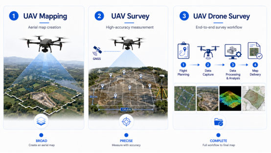
- UAV mapping: The general use of unmanned aircraft to create aerial maps.
- UAV survey: A more accuracy-focused process involving precise positioning and measurement.
- UAV drone survey: A complete workflow covering flight planning, data collection, processing, analysis, and map delivery.
Why Traditional Mapping Methods Fall Short in Emergencies
Emergency teams often need current spatial information within minutes, even when roads are blocked, terrain is unstable, or the affected area is unsafe to enter. Traditional mapping workflows may struggle under these conditions.
Key Operational Challenges
- Information vacuum at T+0: At the beginning of an emergency, teams may rely on dispatch reports, witness accounts, satellite imagery, or outdated maps that do not reflect current damage or changing hazards.
- Physical inaccessibility: Floodwater, debris, collapsed structures, steep terrain, fire, or damaged roads can prevent personnel and vehicles from reaching the affected area.
- Compressed decision windows: Evacuation routes, rescue priorities, perimeter control, and resource deployment may need to be determined within minutes.
Limitations of Conventional Mapping Workflows
- Dependence on vehicle access:Tripods, survey instruments, computers, and power systems can be difficult to transport into mountainous, collapsed, or isolated areas.
- Processing latency: Downloading, transferring, processing, reviewing, and delivering imagery can delay the final map until conditions have already changed.
- Operator dependency:Some UAV survey systems require several specialists to manage the aircraft, survey equipment, data processing, and analysis, creating deployment bottlenecks during emergencies.
Real-time drone mapping reduces these delays by collecting and processing aerial data during the mission, giving response teams faster access to current site conditions.
Key Capabilities for Emergency Drone Mapping
An emergency drone mapping solution should be evaluated based on its ability to meet the practical demands of time-sensitive field operations..
Rapid Deployment and Operational Efficiency
Lightweight equipment, simple connections, and streamlined flight planning can reduce the time from arrival to launch. A single-operator workflow also lowers staffing requirements and supports missions across multiple locations.
Real-Time Mapping and Situational Awareness
The system should generate map coverage during flight rather than relying entirely on post-flight processing. Live imagery, recognition results, and positioning data should be transmitted clearly to the ground station for timely decision-making.
Mapping Accuracy and Intelligent Recognition
Mapping accuracy depends on camera quality, flight altitude, image overlap, aircraft stability, positioning technology, and processing algorithms. Intelligent recognition can help identify people, vehicles, and hazard points, especially when results are linked to coordinates and displayed on the map.
Reliable Performance in Emergency Environments
Portable power, offline operation, aircraft compatibility, and efficient data export improve reliability in remote areas. Organizations should also consider aviation regulations, cybersecurity, data ownership, operator training, and agency procedures before deployment.
How Hunter Wing Supports Real-Time Emergency Mapping
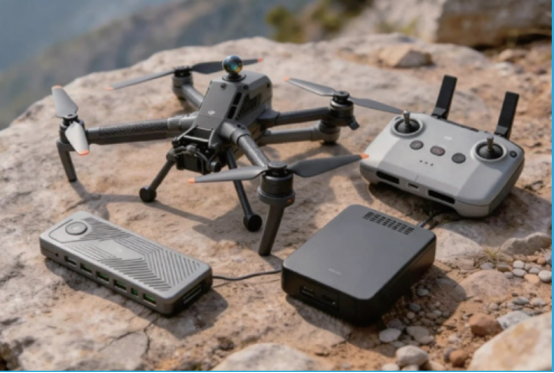
IceCypress developed the Hunter Wing Man-Portable UAV Mapping & Recognition System for real-time mapping, target recognition, and precise positioning. Its AI Computing Box connects to compatible DJI industrial UAV series through a three-step workflow: power on, connect, and set the flight route.
· Rapid, Single-Operator Deployment
The computing module and power supply weigh less than 600 g, allowing one operator to carry and deploy the system in terrain that vehicle-based equipment may not reach. Its simplified setup also reduces dependence on specialist teams during urgent missions.
· Integrated Mapping, Recognition, and Positioning
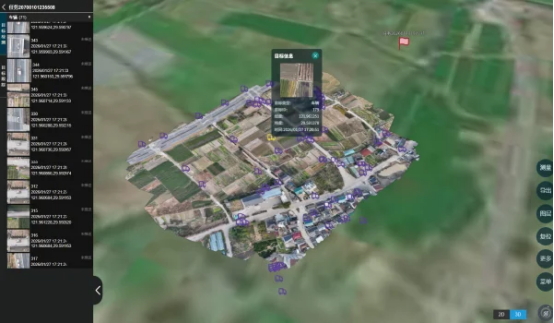
Hunter Wing generates orthomosaic maps while performing target recognition and positioning during flight. Customizable algorithms can identify people, vehicles, hazard points, and other mission-specific targets, with a stated recognition response time of no more than 0.5 seconds. Results and coordinates are transmitted to the ground station in real time.
· High-Precision Situational Intelligence
Detected targets can be positioned with sub-meter-level accuracy and displayed directly on the orthomosaic map. This helps responders understand both what has been identified and where it is located without reviewing imagery separately.
· Portable Performance for Complex Missions
The AI Computing Box consumes less than 25 W and supports up to four hours of operation with a 24 V, 2000 mAh mobile battery. It also supports offline, single-operator mapping, with complete results available immediately after the mission and no separate offline processing step required.
Applications of Real-Time Drone Mapping
The same drone mapping capabilities can support a range of missions that require current and location-based information.
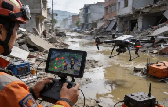
- Emergency Response: Responders can assess damage, inspect routes, locate people, and support rescue, evacuation, and resource deployment.
- Environmental Monitoring:UAV mapping can track changes in rivers, forests, coastlines, pollution, vegetation, and terrain.
- Security Patrol: Drone mapping helps monitor large areas and identify people, vehicles, or unusual activity.
- Construction Sites: A UAV drone survey provides updated views of site progress, access, equipment, and safety conditions.
Conclusion
Real-time drone mapping gives first responders faster access to current site information for damage assessment, route planning, rescue, and resource deployment. Ice Cypress Hunter Wing combines portable deployment, real-time mapping, AI recognition, and precise positioning in a single-operator system.
Contact Ice Cypress to learn more about its emergency mapping capabilities.
FAQs
- Is Drone Mapping the Same as a UAV Survey?
Not exactly. Drone mapping focuses on creating products such as orthomosaics and terrain maps, while a UAV survey usually involves stricter measurement, accuracy, and validation requirements.
- How Accurate Is Real-Time Drone Mapping?
Accuracy depends on the aircraft, camera, flight altitude, positioning method, image overlap, control points, and processing workflow. Hunter Wing supports sub-meter target positioning, but this does not represent the accuracy of every map or mission.
- Can One Operator Complete an Emergency Mapping Mission?
Yes, provided the equipment, regulations, and operating procedures allow it. Hunter Wing is designed for single-operator mapping, recognition, and positioning.
- How Quickly Can a Real-Time Mapping System Generate Usable Maps?
Map coverage and recognition results can be viewed during the flight. Hunter Wing also provides complete mission results without a separate offline-processing stage.
- Do First Responders Need Surveying Knowledge?
Not always. Simplified systems can support situational awareness without advanced surveying expertise, but survey-grade or engineering projects still require qualified procedures and accuracy validation.
References
- National Institute of Standards and Technology. Uncrewed Aircraft Systems.
https://www.nist.gov/ctl/pscr/research-portfolios/uncrewed-aircraft-systems - S. Geological Survey. Guidelines for Calibration of Uncrewed Aircraft Systems Imagery.
https://pubs.usgs.gov/publication/ofr20231033/full






