ICE CYPRESS

Rusa Rapid 3D Scene Reconstruction System

For traffic-accident workflows, Rusa can also serve as high-fidelity accident reconstruction software for scene documentation, measurement, and post-incident analysis.

Lightweight Capture · Centimeter-Level Measurement · Rapid 3D Reconstruction · Flexible Field Deployment

3-Step 3D Accident Reconstruction Workflow

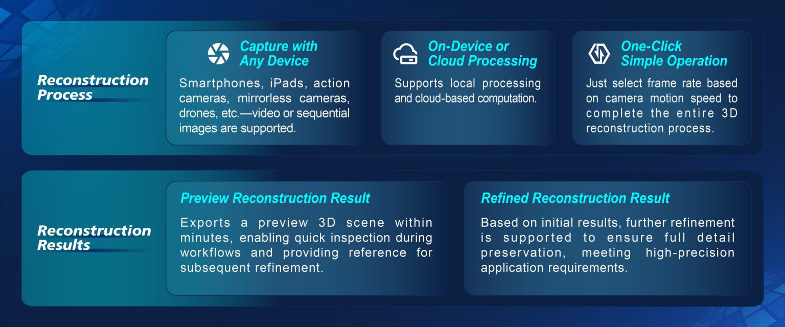
Rusa streamlines the workflow from data capture and processing to preview and final 3D output, reducing manual steps and simplifying field reconstruction.

3-step workflow: capture, processing, preview and refined accident reconstruction results

From field capture to preview and refined output, Rusa simplifies the reconstruction workflow using supported cameras and mobile capture devices.

Flexible Capture for Rapid 3D Reconstruction

Rusa supports flexible field data capture and converts imagery or video into measurable 3D scene models within a streamlined workflow.

  • Flexible capture — Collect imagery or video using supported cameras or mobile devices without dedicated surveying hardware.
  • Adaptive Frame Extraction — Adjust frame extraction based on capture speed and scene conditions.
  • Adaptable Field Operation — Designed for use across a range of field and lighting conditions.
  • Rapid Preview — Generate a preview model in minutes to check scene coverage before leaving the site.

That accessibility is what lets a serious scene reconstruction software feel as usable in the field as familiar accident reconstruction app.

Aerial Triangulation Processing · Stable & Efficient

Four Core Capabilities for Rapid Scene Reconstruction

From minute-level modeling and high-fidelity rendering to AI recognition and centimeter-level measurement, Rusa brings four core capabilities together—turning everyday footage into precise, ready-to-use scene reconstruction results.

Fast 3D Reconstruction: Minute-Level Efficient Modeling
Rapid & Adaptable

Rapid 3D Reconstruction: Preview in Minutes

  • Innovative reconstruction technology simplifies the workflow and reduces manual adjustment, enabling rapid reconstruction and preview model export within minutes.


  • High-precision reconstruction delivers detailed scene models in as little as 40 minutes for high-accuracy application scenarios.


  • Adaptive frame extraction automatically adjusts to different capture speeds, supporting flexible data collection across a range of field conditions.
High-Fidelity Visualization

High-Fidelity Rendering: Detailed Scene Visualization

  • The self-developed 3D viewer renders point-cloud data as high-fidelity 3D scenes with detailed textures and realistic lighting for interactive analysis.


  • Real-time rendering at ≥30 fps supports smooth visualization and interaction across complex, large-scale 3D scenes.
High-Fidelity Rendering: Immersive Scene Restoration
AI Intelligent Recognition: Precisely Focus on Key Elements
AI-Assisted Detection

AI-Assisted Detection: Focus on Key Scene Elements

  • AI-assisted detection identifies supported scene elements such as tires, obstacles, traffic signs, and road damage, helping users quickly focus on key objects of interest.


  • Irrelevant scene elements can be hidden or filtered to reduce visual clutter and keep attention on the features that matter most during analysis.
 
Precise & Measurable results

Precise Measurement: Centimeter-Level Accuracy

  • Supports measurement errors below 2 cm under specified conditions, with tools for length, area, volume, true distance, horizontal distance, and multi-point measurement.


  • The integrated 3D viewer supports zooming, panning, rotation, direct measurement annotation, custom reports, and multi-format export for review, documentation, and data sharing.
Precise Measurement: Centimeter-Level Data Guarantee

3D Scene Reconstruction vs. Traditional Field Surveying

 The choice between manual field surveying and 3D scene reconstruction affects capture time, measurement workflows and how thoroughly the site can be documented.

DimensionTraditional MethodRusa
Time on SceneRoad closure for hours.Capture and model in minutes.
Equipment & Skill RequirementsRequires survey equipment and specialists.No specialized equipment required.
Measurement AccuracyManual point-by-point measurements.Accuracy within 2 cm.
Permanent RecordStatic sketches and reports.Reusable, measurable 3D scene.
ICE CYPRESS

Application Scenarios

From traffic accidents and crime scenes to cultural relics and construction sites, Rusa adapts to diverse real-world environments—serving as practical traffic accident reconstruction tools for emergency response while extending the same rapid, high-precision capture to judicial, cultural, and engineering fields.

Emergency Response Scenarios: Traffic Accidents / Fires / Social Disaster Sites

Traffic Accidents / Fires / Disaster Sites

Rapid field capture and 3D accident reconstruction create measurable scene records for accident analysis, documentation, and evidence review.

Judicial & Criminal Investigation Scenarios: Criminal Crime Scenes

Forensic & Criminal Investigation

High-fidelity 3D reconstruction preserves scene details and supports AI-assisted feature detection, centimeter-level measurement, and long-term digital documentation for investigation and forensic review.

Cultural Preservation Scenarios: Cultural Relic Digitization

Cultural Heritage Digitization & Preservation

Non-contact capture reduces physical interaction with cultural assets, while detailed 3D reconstruction supports digital archiving, virtual display, documentation, and academic research.

Construction Engineering Scenarios: Construction Progress / Decoration Design / Project Acceptance

Construction & Engineering Applications

Rapid site reconstruction and precise measurement support progress documentation, design verification, dimensional review, and project management throughout construction workflows.

Who Uses Rusa?

Rusa is designed for teams that need to turn real-world scenes into measurable, reusable 3D data.

  • Traffic police & emergency responders — Use Rusa as accident investigation software and vehicle accident reconstruction software for rapid scene capture, measurable reconstruction, and post-incident analysis.
  • Criminal investigators & forensic teams — Create detailed, measurable 3D records for scene review and evidence documentation.
  • Cultural heritage teams — Support non-contact documentation, digital archiving and academic study.
  • Construction & engineering teams — Support progress documentation, dimensional verification and project review.

The same reconstruction workflow can be applied across scenes ranging from individual incidents to larger disaster, heritage and construction sites.

Frequently Asked Questions

Rusa exports custom reports and multiple formats, so results travel into common downstream tools; for a specific system, it's best to check with our team before you commit.

It's built for all-weather capture, but real-world conditions vary, so for a scene like yours, we'd suggest discussing expected results with our engineers.

No—it identifies and isolates key elements and gives objective measurements, but fault is left to the investigator's judgment, not the software.

Many teams adapt it to their existing processes; share your workflow with us and we'll advise what's feasible.

Contact Us

Discuss Your Project with Our Team

Share your application, project environment and technical requirements.

Follow Us :