
Map While Flying, Detect Without Waiting
After a flood, roads are cut, terrain reshaped, comms down—rescue teams face…


We create a 3D foundation using independent technologies. Our spatial artificial intelligence solutions drive real industry change, making low-altitude space more efficient, secure, and smart.
Spatial 3D+AI End-to-End Solutions, Empowering Industry Digital Upgrade
Fortify the 3D Foundation with Independent Technologies, Drive Industry Transformation via Intelligent Solutions, and Make Low-Altitude Space More Efficient, Secure, and Smart.

Full core tech ownership, compliant and innovative.

Sub-centimeter accuracy for large-scale 3D digital twin solutions.

Spatial artificial intelligence workflows for data-driven efficiency.

Tailored geospatial intelligence solutions for military & civilian use.
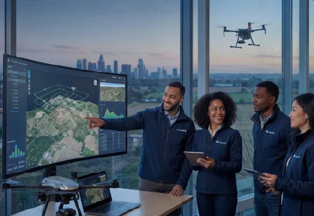
IceCypress is a leading spatial intelligence AI company specializing in 3D and AI. We build a strong digital base with independent core technologies. Our exclusive products excel globally, achieving localized breakthroughs. By merging low-altitude data with drone photogrammetry and 3D + AI, we provide complete geospatial intelligence solutions. This powers the intelligent growth of the low-altitude economy worldwide.
Many geospatial platforms only capture data. IceCypress transforms low-altitude aerial data into decision-ready intelligence. We do this through a fully integrated visual spatial intelligence pipeline.
Our workflow has three stages:
Capture
Multi-UAV clusters execute coordinated drone photogrammetry missions, collecting high-overlap aerial imagery with centimeter-level GPS positioning across large-scale areas.
Reconstruct
Onboard and cloud AI quickly turn raw imagery into photorealistic 3D meshes, point clouds, and orthomosaics—within minutes, not days.
Analyze
Spatial AI models add semantic understanding to 3D geometry. They detect anomalies, track changes over time, and generate structured outputs for downstream decision systems.
This pipeline removes the manual bottlenecks of traditional surveying. We deliver scalable, audit-ready geospatial intelligence solutions across energy, infrastructure, and public safety sectors.

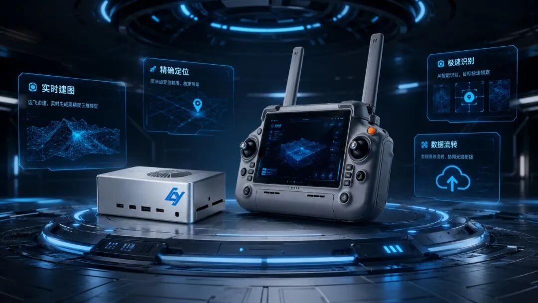
Edge-intelligent UAV photogrammetry cluster system, enabling multi-UAV collaboration, real-time reconstruction, and precise positioning.
We capture accurate motion trajectories and analyze target postures, enhancing decision-making with our aerial intelligence platform.

This lightweight system achieves centimeter-level accuracy, enabling 8-minute AI 3D reconstructions with high detail.

Our urban-scale modeling delivers survey-grade results, combining multiple data sources into a complete 3D digital twin solution.
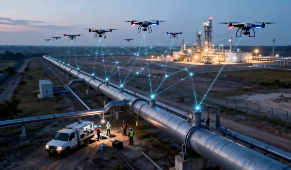
Pipeline inspection, mine operation & maintenance — geospatial intelligence solutions deliver high-precision modeling to safeguard asset safety.
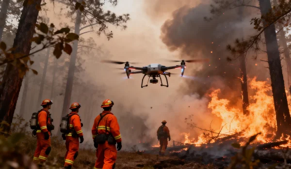
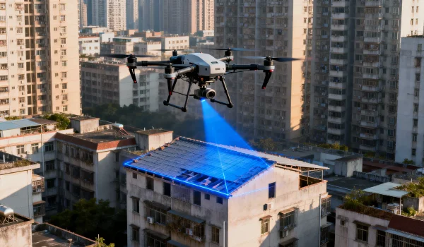
Rapid disaster-site modeling, situational awareness — our aerial intelligence platform supports scientific decision-making and on-ground rescue.
Urban surveying, illegal construction inspection — spatial analysis in geography enables high-precision modeling for compliant governance.
Leverage our drone photogrammetry and spatial intelligence solutions to enhance efficiency and innovation in your business.
Choosing the right data collection method affects project costs, turnaround times, and accuracy. Here’s how UAV photogrammetry stacks up against conventional methods:
| Dimension | Traditional Ground Survey | Manned Aerial Survey | UAV Photogrammetry (IceCypress) |
| Coverage Speed | Low — days per km² | Medium — hours per flight | High — minutes per km² |
| Accuracy | High, point-by-point | Medium | Sub-centimeter with RTK/PPK |
| Hazardous Area Access | Limited | Limited | Full access — no human risk |
| 3D Output | Manual CAD drafting | 2D ortho only | Automated AI 3D reconstruction |
| Update Frequency | Quarterly at best | Costly to repeat | On-demand, repeatable missions |
| Integration with Digital Twin | Manual import | Partial | Native pipeline integration |
For asset-intensive industries—like energy pipelines and urban infrastructure—drone photogrammetry paired with IceCypress’s AI processing is why leading enterprises choose us as their digital twin solution providers for asset-intensive operations.
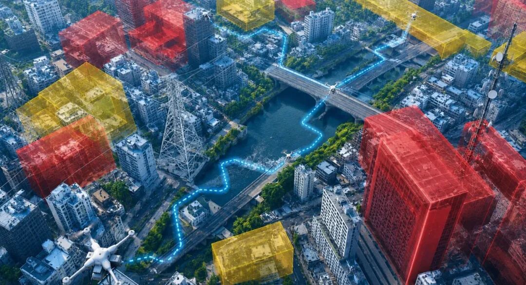
Powered by DroneSwarm, our platform delivers real-time 2D/3D modeling and AI target location. This addresses tight rescue timelines, enhancing situational awareness and visual decision-making.
Our mine 3D digital twin solution, integrated with Mirauge3D GIS models and AI/IoT, promotes safe, efficient operations. We turn complex site data into actionable insights.
An air-land-sea perception network, combined with UAV photogrammetry and AI-driven closed-loop management, upgrades pipeline inspection to fully intelligent, traceable digital operations.
AI-powered illegal detection based on digital twins builds an efficient closed-loop supervision platform, enhancing governance accuracy.
Digital twin + GIS/AI visualizes real-time water data, enabling intelligent early warning and efficient full-link operations.

We used Mirauge3D to process 440,000 images for 27km² 3D reality modeling in Shantou’s planning. It maintained an ultra-high aerial triangulation success rate amid complex scenarios (weak texture, large elevation differences, narrow strips, few GCPs), meeting requirements flawlessly.

Mirauge3D (oblique photography tool) excels in stability, success rate and precision. It resolves industry pain points (fractures, layering, bending, edge matching) in large-area modeling, simplifies workflows, reduces complexity, and boosts efficiency significantly.


Lorem ipsum dolor sit amet, consectetur adipiscing elit. Ut elit tellus, luctus nec ullamcorper mattis, pulvinar dapibus.
After a flood, roads are cut, terrain reshaped, comms down—rescue teams face…
In 2026, the low-altitude economy shows no sign of cooling. Vertiports, industrial…

TrackSight High-Speed Target Tracking & Analytics System (TrackSight) Independently developed by ICE…
After you submit your project requirements, our team usually responds within 24 hours. For complex projects, a tailored proposal follows an initial consultation.
Yes, our products are built for global use. They handle diverse terrains, multi-language environments, and international compliance. We actively partner with overseas organizations in government, energy, and infrastructure sectors.
Our spatial intelligence platform combines perception across air, land, and sea with AI-driven anomaly detection. It fully digitizes pipeline inspections, replacing manual checks with automated management, enhancing coverage and safety.
In emergencies, our DroneSwarm enables rapid 2D/3D site modeling within minutes. AI-powered target location and real-time mapping provide rescue teams with the spatial awareness they need.
Unlike traditional UAVs, DroneSwarm allows edge-intelligent onboard computing. Multiple drones collaborate in real time to perform reconstruction, target positioning, and data analysis during flight, without relying on ground processing.
Tell us about your project or inquiry, and our team will get back to you within 24 hours.
Follow Us :
Let’s discuss how our smart solutions can drive your business forward. Our team is ready to provide tailored technical and business support.


Excellence in Provider of Spatial Intelligence Products & Solutions
Copyright © 2026 Ice Cypress All rights reserved