

In 2026, the low-altitude economy shows no sign of cooling. Vertiports, industrial parks, and pilot projects are rolling out nationwide—yet a more fundamental gap is coming into view.
Low-altitude airspace is no blank canvas. Buildings, bridges, power lines, comms towers, ridges, shifting weather, population density, no-fly and restricted zones—these slice the seemingly open sky into countless fragmented, ever-shifting usable parcels.
Whether an aircraft can transit safely, whether routes can be planned efficiently, and whether missions can run routinely—all boil down to one prerequisite: Can we turn low-altitude airspace into a computable digital model?

This is “Airspace Digitization”
It does not grab attention the way airframes do, yet it is the most underestimated layer of the low-altitude economy’s foundation.
Industry conversations today still cluster around airframe performance, vertiports, and policy push. But one thing is increasingly clear: even if the aircraft side matures, scale operations cannot happen without granular awareness of the low-altitude environment.
Every real flight must answer the same preflight questions: What obstacles lie along the route? Is comms coverage solid? Do weather conditions hold? Where exactly do the no-fly boundaries run? Today, in most regions, these answers still come from experience and ad-hoc surveys.
These answers cannot be produced case by case by human hands. They must settle into a callable, reusable data capability—and that is exactly what the platform layer exists to solve.
High-resolution remote sensing, 3D real-scene modeling, automated obstacle detection, airspace grid partitioning, 3D route planning, real-time flight monitoring, risk alerting—each on its own is a technical point; together, they are a platform engineering effort.
They may not sound like “aviation” per se—yet they are the fault line that decides whether the low-altitude economy moves from pilot to operation.
One line says it: Digitize the airspace first; then industrialize the industry.
IceCypress’s Low‑Altitude 3D Intelligent Operations Platform is built precisely along this direction.
The platform fuses 3D real-scene, BIM, GIS, and IoT with dynamic feeds—weather, airspace rules—to build a 4D spatial situation map, transforming complex physical airspace into a digital model that is perceivable, analyzable, and dispatchable.
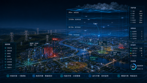
Covering the full cycle—pre-flight planning, in-flight monitoring, post-flight optimization—the platform powers intelligent routing, obstacle risk assessment, real-time 3D monitoring, conflict alerting, and mission replay, pushing low-altitude flight from isolated pilots to systematic operations.
The endgame of the low-altitude economy is not about who flies higher, but who first turns the low-altitude sky into a digital network that can be dispatched, regulated, and operated—continuously.
See the sky clearly. Compute it precisely. Put it to work.—This is the core value ICE CYPRESS aims to deliver as the low-altitude economy enters its second half.





