

The rapid development of emerging technologies is creating new opportunities for industries to expand beyond traditional physical spaces. One of the most promising areas is the low-altitude economy, where drones, artificial intelligence, 3D technologies, and intelligent management systems are reshaping how cities and industries operate.
At Icecypress Technology, we are building the digital foundation needed for this transformation. As a spatial intelligence AI company specializing in 3D and AI, we develop advanced solutions that support the low-altitude airspace economy through real-world 3D modeling, air-ground integration, and intelligent connectivity.
Our goal is to make low-altitude operations safer, smarter, and more scalable. By combining full-domain drone situational awareness, intelligent planning, and safety control technologies, we provide a comprehensive low-altitude platform that helps industries unlock new possibilities in urban management, logistics, emergency response, and other applications.
What Is the Low-Altitude Economy and Why Is It Growing?
The low-altitude economy refers to a new economic model built around activities conducted in low-altitude airspace, typically involving drones, unmanned aerial vehicles, and other low-altitude aircraft. It connects aviation technologies with industries such as transportation, agriculture, infrastructure, public services, and smart cities.
Unlike traditional aviation systems that mainly focus on high-altitude commercial flights, the low-altitude economy emphasizes flexible, frequent, and intelligent operations close to the ground. These activities require advanced digital infrastructure to manage aircraft movement, ensure safety, and improve efficiency.
As drone applications become more widespread, industries need more than individual aircraft. They require complete ecosystems that include airspace management, data processing, route planning, and real-time monitoring.
At Icecypress Technology, we believe intelligent spatial technologies are the key foundation for this development. Through our low-altitude solutions, we help organizations transform complex aerial environments into manageable digital systems.
How Does a Low-Altitude Platform Enable Smarter Air Operations?
A successful low-altitude economy requires a reliable digital management system. A low-altitude platform provides the connection between drones, airspace information, geographic data, and operational services.
Our Low-Altitude 3D Intelligent Operations Platform is designed as a digital infrastructure system for large-scale low-altitude applications. It functions as a “traffic light, controller, and navigation map” for aerial operations by providing comprehensive situational awareness and intelligent control.
The platform integrates three core capabilities: real-scene 3D, air-ground integration, and intelligent connectivity.
Real-scene 3D technology creates accurate digital representations of environments, helping operators understand buildings, terrain, and potential flight conditions. Air-ground integration connects aerial operations with ground-based geographic information and infrastructure data. Intelligent connectivity enables communication between drones, platforms, and management systems.
Together, these capabilities support safer and more efficient commercial low-altitude operations.
Building a Digital Foundation for the Low-Altitude Airspace Economy
The expansion of the low-altitude airspace economy depends on the ability to manage large amounts of spatial and operational data. Traditional geographic systems often cannot provide the real-time understanding required for dynamic drone operations.
At Icecypress Technology, we build a comprehensive spatial data foundation by integrating remote sensing imagery, real-world 3D models, and airspace information. This creates a unified regional low-altitude operation map that supports intelligent decision-making.
Our air-ground integrated geospatial service platform provides three essential capabilities: data fusion, 3D analysis and rendering, and scenario construction.
Data fusion combines different sources of information into one intelligent system. 3D analysis and rendering allow users to visualize environments and evaluate operational conditions. Scenario construction helps organizations develop customized applications based on specific industry needs.
This digital foundation enables cities and enterprises to manage low-altitude activities more effectively.
The “1 Foundation + 1 Platform + N Scenarios” Framework
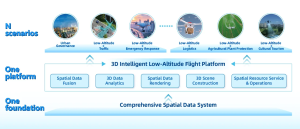
The future of low-altitude operations requires a scalable architecture that can support different industries and applications. We have developed a governance framework based on “1 Foundation + 1 Platform + N Scenarios.”
The first element is the spatial data foundation, which provides comprehensive environmental understanding through integrated geographic and aerial information.
The second element is the intelligent low-altitude platform, which connects data, aircraft, and operational services into one coordinated system.
The final element includes multiple application scenarios. These scenarios cover urban governance, emergency rescue, low-altitude traffic management, logistics services, agricultural plant protection, and cultural tourism.
By supporting diverse applications through one unified architecture, this framework helps cities and organizations develop more intelligent and efficient low-altitude ecosystems.
Supporting Real-World Applications with Spatial Intelligence
The value of the low-altitude economy comes from practical applications. Different industries require different solutions, but they all share a common need: accurate environmental understanding and intelligent decision-making.
For smart city management, low-altitude platforms can support urban monitoring, infrastructure management, and public service optimization. Emergency rescue teams can use intelligent aerial systems to quickly understand disaster areas and improve response efficiency.
In logistics, drone operations require accurate route planning and safety control. Agricultural applications benefit from precise aerial monitoring and intelligent analysis for plant protection.
At Icecypress Technology, we combine 3D AI and spatial intelligence to support these scenarios. Our solutions help organizations move from isolated drone operations toward integrated digital management.
Creating the Future of Intelligent Low-Altitude Operations
The low-altitude economy is becoming an important direction for future industrial development. However, sustainable growth requires more than advanced drones. It requires intelligent infrastructure that can manage complex environments and ensure safe operations.
At Icecypress Technology, we continue to develop independent technologies that strengthen the connection between physical spaces and digital intelligence. Through our low-altitude platform solutions, we provide the tools needed for scalable, commercial aerial operations.
Building a Smarter Sky with Icecypress Technology
The rise of the low-altitude economy represents a major shift in how industries use airspace resources. By combining 3D intelligence, AI, and geospatial technologies, we are helping organizations create safer and more efficient aerial ecosystems.
Icecypress Technology is committed to building the digital foundation behind this transformation. Through our Low-Altitude 3D Intelligent Operations Platform and spatial intelligence solutions, we support the growth of smart cities and global low-altitude applications. As the industry continues to evolve, we will keep advancing technologies that make low-altitude operations more intelligent, connected, and sustainable.






