

Businesses are increasingly relying on digital technologies to understand complex environments, improve operational decisions, and manage physical assets more efficiently. Although spatial intelligence and geospatial intelligence are often discussed together, they represent different approaches to analyzing the world around us. Spatial intelligence focuses on understanding three-dimensional spaces through AI-driven perception and reasoning, while geospatial intelligence emphasizes location-based information analysis.
At Icecypress Technology, we combine 3D reconstruction, artificial intelligence, drone photogrammetry, and low-altitude data processing to bridge these technologies. As a spatial intelligence AI company specializing in 3D and AI, we develop independent core technologies that change raw spatial data into actionable insights. Our spatial intelligence solutions and geospatial intelligence solutions help industries build smarter, safer, and more efficient operations.
What Is Spatial Intelligence and How Does It Work?
Spatial intelligence refers to the ability of technology to perceive, understand, and analyze physical environments in three dimensions. Unlike traditional mapping methods that mainly focus on location information, spatial intelligence adds deeper environmental awareness through AI models.
A spatial intelligence system can process data from drones, cameras, sensors, and other sources to create detailed digital representations. These representations include 3D models, point clouds, and digital twins that reflect real-world conditions.
The key advantage of spatial intelligence is its ability to understand relationships between objects, structures, and environments. AI models can recognize patterns, detect anomalies, monitor changes, and generate structured information for further decision-making.
At Icecypress Technology, we enhance 3D geometry with semantic understanding through spatial AI models. This allows our solutions to move beyond simple visualization and support intelligent analysis for industrial applications.
How Do Geospatial Intelligence Solutions Differ?
Geospatial intelligence, commonly known as GEOINT, focuses on collecting, processing, and analyzing information related to geographic locations. It combines satellite imagery, aerial data, geographic information systems (GIS), and other location-based technologies.
Geospatial intelligence solutions are widely used in industries where understanding terrain, infrastructure locations, and geographic changes is essential. They support applications such as urban planning, environmental monitoring, defense, resource management, and infrastructure maintenance.
While GEOINT provides valuable geographic awareness, modern applications require more than location data. Companies need systems that can interpret physical environments, identify risks, and support real-time operational decisions.
This is where advanced spatial intelligence solutions create additional value. By combining geospatial information with 3D reconstruction and AI analysis, organizations can gain a more complete understanding of physical spaces.
Spatial Intelligence Solutions Combine 3D Data With AI Understanding
The major difference between traditional geospatial intelligence and spatial intelligence is the level of understanding. GEOINT answers questions such as “Where is an object located?” Spatial intelligence expands this capability by answering “What is happening in this environment, and what action should be taken?”
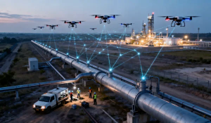
Our approach at Icecypress Technology integrates drone photogrammetry with 3D + AI technologies. Through this workflow, we collect high-quality aerial data, reconstruct detailed digital environments, and apply AI models for intelligent analysis.
Our technology pipeline includes three essential stages: capture, reconstruction, and analysis. Multi-UAV systems collect aerial imagery with precise positioning. AI-powered processing then converts this data into realistic 3D models, meshes, and orthomosaics. Finally, spatial AI models analyze these environments to identify changes and provide structured outputs.
Why Industries Need Advanced Geospatial Intelligence Solutions
Many industries operate in environments where accurate monitoring and timely decisions are critical. Traditional inspection and surveying methods often require significant manual effort and may not provide continuous visibility.
For example, pipeline inspection requires accurate identification of structural issues across large and difficult-to-access areas. Mining operations require continuous monitoring of terrain, equipment, and production conditions. In these scenarios, geospatial intelligence solutions provide high-precision modeling capabilities that improve asset safety and operational efficiency.
At Icecypress Technology, we use 3D digital twins and AI-powered analysis to help organizations transform complex physical environments into measurable digital assets. Our solutions support pipeline inspection, mine operation and maintenance, emergency response, urban governance, and other industrial scenarios.
Our 3D AI Product Ecosystem Supports Intelligent Decision-Making
Building effective spatial intelligence requires a complete technology foundation. At Icecypress Technology, we have developed a product ecosystem covering data collection, 3D reconstruction, and intelligent analysis.
Our DroneSwarm Real-Time Onboard Analysis System enables multi-UAV collaboration, real-time reconstruction, and precise positioning. Mirauge3D provides urban-scale high-precision 3D modeling by integrating multiple data sources. Rusa delivers rapid scene reconstruction with centimeter-level accuracy, while TrackSight focuses on high-speed target tracking and trajectory analysis.
These technologies allow businesses to move from passive data collection toward proactive intelligence. Instead of simply viewing geographic information, users can understand changes, predict risks, and optimize operations.
Building the Future With Integrated Spatial and Geospatial Intelligence
The future of digital transformation depends on the ability to connect physical environments with intelligent computing. Spatial intelligence and geospatial intelligence are not competing technologies. Instead, they complement each other to create more powerful solutions.
Geospatial intelligence provides the geographic foundation, while spatial intelligence adds AI-based perception and understanding. Together, they enable organizations to manage complex environments with higher accuracy and efficiency.
At Icecypress Technology, we continue developing independent 3D and AI technologies to support the growth of the global low-altitude economy. By combining low-altitude data, drone photogrammetry, and intelligent analysis, we deliver complete spatial intelligence solutions and geospatial intelligence solutions for modern industries.
Our goal is to help businesses change spatial data into practical intelligence, making operations safer, smarter, and more sustainable. As industries demand deeper environmental awareness, the integration of 3D AI and geospatial technologies will become a critical foundation for future innovation.






