

Rapid access to accurate data has become essential for industries that rely on unmanned aerial vehicles (UAVs). At Icecypress Technology, we are developing advanced spatial intelligence solutions that combine 3D technologies, artificial intelligence, and edge computing to improve how organizations collect, process, and utilize drone data. Our DroneSwarm Real-Time Onboard Analysis System enables efficient drone data analytics by supporting real-time mapping, target recognition, positioning, and collaborative UAV operations.
The Growing Need for Real-Time Drone Data Analytics in Modern Applications
Traditional drone operations often focus on data collection first and analysis later. While this approach can provide valuable information, delayed processing may reduce the effectiveness of decision-making in time-sensitive scenarios. Industries such as emergency response, environmental monitoring, infrastructure inspection, and security require faster access to actionable insights.
Drone data analytics addresses this challenge by processing and interpreting aerial data more efficiently. Instead of transferring all collected information to remote servers for later analysis, intelligent systems can analyze key information during flight. This reduces unnecessary data transmission and allows operators to respond faster.
At Icecypress Technology, we focus on creating independent core technologies based on spatial intelligence AI. By integrating onboard computing, intelligent algorithms, and UAV collaboration, we help organizations transform raw drone data into meaningful operational intelligence.
How Our DroneSwarm System Enables Faster Data Processing
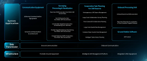
Our DroneSwarm Real-Time Onboard Analysis System is designed as an edge-intelligent UAV cluster solution for precision drone data acquisition and real-time monitoring. The system allows multiple UAVs to work together while performing advanced analysis tasks during operations.
One of its core capabilities is multi-UAV collaborative real-time 2D and 3D reconstruction. Multiple drones can collect data from different perspectives and combine information to generate detailed spatial models. This improves visibility in complex environments and supports more accurate analysis.
Unlike conventional workflows that depend heavily on post-processing, our system performs intelligent analysis closer to the data source. This onboard processing capability helps reduce latency and allows teams to receive important information while missions are still underway.
Why Real-Time Monitoring Systems Improve UAV Workflows
Effective UAV operations require more than collecting images or videos. Organizations need a complete workflow that connects communication, navigation, control, analysis, and decision-making. This is where real-time monitoring systems become valuable.
Our DroneSwarm architecture integrates communication, navigation, and control (CNC) functions to create a coordinated operational framework. Through this integration, UAV teams can maintain better control over multiple aircraft while ensuring continuous information exchange.
The system supports full-process closed-loop operations across the entire UAV swarm. From onboard data acquisition and processing to ground-based management and command, each stage works together to improve efficiency and reliability.
For industries managing large-scale UAV deployments, this integrated workflow reduces operational complexity and creates a stronger foundation for intelligent aerial applications.
Reducing Latency Through Edge Computing and Intelligent Analysis
Latency is one of the most important factors affecting drone-based decision-making. When data must travel long distances before analysis, valuable time may be lost. Edge computing provides a practical solution by allowing processing tasks to happen closer to where data is generated.
At Icecypress Technology, we apply edge intelligence to improve real-time performance. Our DroneSwarm system supports onboard analysis, allowing UAVs to recognize targets, determine locations, and track changes during flight.
Target recognition, positioning, and tracking are key functions that help operators understand changing situations. By processing video streams and spatial information in real time, the system can provide more accurate operational feedback.
This approach is particularly useful in scenarios where rapid response is required. Whether monitoring large areas or supporting emergency operations, lower latency enables faster and more effective decisions.
Building Reliable UAV Tracking and Positioning Capabilities
Accurate UAV tracking and positioning are essential for successful air-ground collaboration. Without reliable location information, even high-quality aerial data may be difficult to apply effectively.
Our UAV tracking and UAV positioning system creates a multi-tiered architecture that connects onboard processing with ground-based command. This structure improves coordination between drones and management platforms, allowing operators to monitor UAV status and mission progress more effectively.
By combining intelligent onboard systems with centralized management, we support more reliable swarm operations. Each UAV can contribute data while remaining connected within a unified command framework.
This capability helps organizations manage complex missions involving multiple aircraft, improving both operational safety and data accuracy.
The Future of Intelligent Drone Operations with Icecypress Technology
The development of intelligent UAV systems is changing how industries collect and use spatial information. As demand for faster insights continues to grow, technologies such as AI, edge computing, and real-time monitoring systems will become increasingly important.
At Icecypress Technology, we are committed to advancing spatial intelligence through 3D reconstruction, AI algorithms, and autonomous drone collaboration. Our DroneSwarm solution helps organizations move beyond simple aerial data collection toward intelligent analysis and real-time decision support.
By improving drone data analytics, reducing processing delays, and strengthening UAV tracking capabilities, we aim to build more efficient and reliable solutions for complex operational environments. Through continuous innovation, we help businesses unlock the full potential of drone technology and create smarter workflows for the future.






