

Growing demand for faster and more accurate information is changing how industries monitor environments, manage resources, and respond to complex challenges. At Icecypress Technology, we combine spatial intelligence, 3D technologies, and artificial intelligence to create advanced solutions for intelligent data acquisition. Our DroneSwarm Real-Time Onboard Analysis System helps organizations collect, process, and analyze aerial data efficiently through multi-UAV collaboration, real-time mapping, and intelligent computing.
As a spatial intelligence AI company, we build a strong digital foundation with independent core technologies. Through innovative drone solutions, we help businesses turn raw aerial information into valuable insights for decision-making, monitoring, and emergency response.
Understanding the Role of Drone Data Collection in Modern Industries
Traditional data acquisition methods often require significant manpower, time, and resources, especially when operating in large, complex, or hazardous environments. Drone technology provides a more flexible approach by enabling aerial observation, automated surveying, and continuous monitoring.
Drone data collection refers to the process of using unmanned aerial vehicles (UAVs) to capture information from physical environments through cameras, sensors, positioning systems, and other intelligent devices. The collected data can include images, videos, terrain information, and spatial data that support various industrial applications.
However, collecting data is only the first step. Modern organizations require faster processing and deeper understanding of information. This is where drone data analytics becomes essential. By applying artificial intelligence and advanced computing technologies, businesses can convert large volumes of aerial data into meaningful insights.
How Our DroneSwarm System Improves Aerial Data Acquisition
At Icecypress Technology, we developed DroneSwarm as an edge-intelligent UAV cluster system designed for precision drone data acquisition and real-time monitoring. Unlike traditional single-drone operations, our system enables multiple UAVs to collaborate, improving efficiency and expanding operational capabilities.
The DroneSwarm Real-Time Onboard Analysis System supports multi-UAV collaborative real-time 2D and 3D mapping. Multiple drones can work together to collect environmental information and generate detailed spatial models during operations.
This capability is valuable for industries that require accurate geographic understanding, including emergency rescue, infrastructure inspection, environmental monitoring, and complex site management. By reducing manual processes and improving data collection speed, organizations can achieve more efficient operations.
Multi-UAV Collaboration Enables Real-Time Mapping and Reconstruction
Large-scale projects often require comprehensive environmental information. A single drone may face limitations in coverage area, flight duration, or processing capability. Multi-UAV collaboration provides a more effective solution by allowing multiple drones to complete tasks together.
Our DroneSwarm system supports multi-UAV collaborative real-time 2D/3D reconstruction. Through coordinated flight and onboard computing, drones can collect and process spatial information simultaneously.
This approach improves operational efficiency by reducing the time required for surveying and mapping tasks. It also enhances data quality by combining information from multiple perspectives, creating a more complete understanding of the target environment.
With the support of AI technologies, the system can perform target recognition, positioning, and tracking. This allows operators to identify important objects, monitor changes, and respond quickly based on accurate information.
How Drone Data Analytics Enhances Decision-Making
The value of aerial information depends on how effectively it can be analyzed and applied. Drone data analytics helps organizations extract useful insights from collected data by using artificial intelligence, machine learning, and spatial analysis technologies.
At Icecypress Technology, we integrate intelligent analysis capabilities into our UAV solutions. Instead of only capturing images or videos, our system can process information during missions through drone edge computing.
Real-time onboard analysis reduces dependence on remote data processing and improves response speed. This is especially important for time-sensitive scenarios where immediate decisions are required.
Through intelligent recognition, positioning, and tracking, our technology helps users understand operational conditions more clearly. Whether monitoring a large area or supporting emergency response, drone data analytics provides a stronger foundation for accurate planning and execution.
Intelligent Multi-UAV Path Planning Improves Mission Efficiency
Coordinating multiple drones requires advanced planning capabilities. Different environments, mission objectives, and UAV types create complex operational challenges. Effective path planning ensures that drones can complete tasks safely while maximizing efficiency.
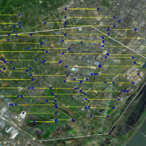
Our multi-UAV path planning engine independently generates optimal flight paths based on UAV performance and environmental perception. The system can dynamically optimize speed, altitude, and coverage density according to mission requirements.
It also supports task re-planning and UAV swarm re-grouping during emergency situations. When operational conditions change, the system can adjust strategies quickly to maintain mission effectiveness.
In addition, our intelligent dispatching capability supports unified control of multirotor, fixed-wing, and hybrid UAV formations. This flexibility allows the solution to adapt to different application scenarios and operational requirements.
Efficient Surveying and Mapping Through Intelligent Coordination
Large-scale surveying requires accurate positioning and efficient resource allocation. Our DroneSwarm system uses intelligent zoning based on terrain conditions and UAV capabilities to improve mission performance.
By optimizing route overlap and flight coverage, the system helps reduce unnecessary operations while maintaining high-quality data collection. Precise UAV positioning ensures that collected information remains accurate and reliable.
This efficient approach benefits organizations that need large-area monitoring, 3D reconstruction, or rapid environmental assessment. Through intelligent coordination, multiple drones can complete complex missions with improved speed and accuracy.
Creating Smarter Data Solutions With Icecypress Technology
The future of aerial intelligence depends on the combination of advanced drones, artificial intelligence, and spatial computing. At Icecypress Technology, we continue developing independent technologies to help businesses achieve more intelligent operations.
Our DroneSwarm Real-Time Onboard Analysis System provides comprehensive capabilities for drone data collection, including collaborative mapping, intelligent path planning, target recognition, and real-time edge computing.
As industries increasingly rely on accurate and timely information, drone data analytics will become an important tool for improving efficiency and decision-making. We are committed to delivering spatial intelligence solutions that help organizations better understand their environments and respond to challenges with greater confidence.






