

Public safety and inspection teams increasingly need faster, more accurate, and more flexible tools to handle complex field environments. From emergency response and security patrols to infrastructure inspections and environmental monitoring, traditional methods often struggle to provide real-time situational awareness. Lightweight unmanned aerial vehicle solutions are changing how teams collect information, identify targets, and make operational decisions.
At Icecypress Technology, we develop cutting edge spatial intelligence solutions by combining 3D technology, artificial intelligence, and drone data processing. Our Hunter Wing man-portable UAV solution is designed for drone reconnaissance and recognition missions, helping operators obtain real-time mapping, object detection, and precise positioning capabilities in demanding environments. By integrating AI computing with aerial platforms, we support more efficient public safety and inspection operations.
What Makes a Man-Portable UAV Valuable for Field Operations?
A man-portable UAV is designed to provide mobility, rapid deployment, and operational flexibility. Unlike larger unmanned systems that require complex transportation and setup procedures, portable UAV solutions can be carried and operated by a single person.
For public safety teams, this mobility is essential during emergency situations where response speed directly affects outcomes. Search and rescue missions, disaster assessments, and security operations often take place in unpredictable environments where access is limited. A lightweight UAV enables teams to quickly gather aerial intelligence without waiting for additional equipment or specialized support.
Inspection teams also benefit from portable drone technology. Infrastructure, environmental, and industrial inspections often cover large or difficult-to-reach areas. A compact UAV system allows operators to collect accurate information while reducing manual inspection risks and improving efficiency.
At Icecypress Technology, we focus on creating lightweight aerial intelligence solutions that simplify field operations while maintaining professional-level data processing capabilities.
How Does the Hunter Wing Man-Portable UAV Improve Reconnaissance?
The Hunter Wing man-portable UAV is built for drone reconnaissance and recognition applications. It provides an offline, single-operator solution that combines aerial data collection with intelligent analysis.
One of its key capabilities is real-time orthomosaic drone mapping. By processing aerial imagery quickly, the system creates accurate visual representations of operational areas. This allows teams to understand terrain conditions, monitor changes, and support decision-making during missions.
The system also delivers ultra-fast drone object detection and accurate target positioning. Through AI-powered recognition technology, operators can identify important objects and locations more efficiently compared with traditional manual observation methods.
For public safety applications, these capabilities provide valuable support during emergency response, security patrols, and field investigations. Teams can quickly understand their surroundings and mark important locations with improved accuracy.
Why Do Public Safety Teams Need Advanced Drone Intelligence?
Public safety operations require reliable information under challenging conditions. Whether responding to natural disasters, conducting search missions, or managing security tasks, teams need technology that can provide immediate awareness of the environment.
A modern public safety drone software system helps change drone-collected data into actionable intelligence. Instead of only capturing images or videos, advanced software can analyze information, identify targets, and provide location-based insights.
Our solutions combine drone recognition, spatial intelligence, and AI computing to enhance operational capabilities. By connecting drone platforms with intelligent processing systems, we help public safety teams move from passive observation to active decision-making.
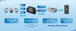
The Hunter Wing solution supports rapid deployment by connecting an AI Computing Box directly to the drone remote control. Operators can quickly perform situational awareness, target inspection, and location marking without complex hardware modifications or extensive training.
What Features Should Inspection Teams Consider When Selecting UAV Solutions?
Inspection teams require UAV systems that balance accuracy, convenience, and adaptability. A successful solution should not only capture high-quality data but also support efficient analysis and operational workflows.
First, portability is important. A man-portable UAV should be lightweight and easy to transport between different inspection locations. This allows teams to respond quickly to changing requirements.
Second, compatibility is essential. Many organizations already use industrial drones and need solutions that integrate smoothly with existing equipment. Hunter Wing is designed to be compatible with mainstream industrial drones without requiring hardware modifications.
Third, intelligent processing capabilities create long-term value. Real-time mapping, object recognition, and positioning features reduce the time required to interpret aerial information. This helps inspection teams complete tasks faster and improve reporting accuracy.
By combining these capabilities, our UAV solutions provide practical support for infrastructure inspections, environmental monitoring, and other professional applications.
Supporting Multiple Scenarios With Flexible UAV Technology
Different industries face different operational challenges, which is why flexibility is a critical requirement for modern UAV systems. A single platform should support multiple applications while maintaining simple operation.
Our man-portable UAV solution is designed for all-scenario compatibility. It integrates real-time orthomosaic drone mapping, drone recognition, and precise positioning in a lightweight package. The system enables users to collect and analyze spatial information across various environments.
For emergency rescue teams, it provides rapid aerial awareness when time is limited. For security teams, it supports patrol operations and target identification. For environmental inspection teams, it enables efficient monitoring of large areas.
This versatility allows organizations to maximize the value of their drone investments while reducing operational complexity.
Building Smarter Field Operations Through AI and Spatial Intelligence
The future of public safety and inspection depends on combining aerial mobility with intelligent data analysis. Drones provide valuable perspectives from the air, but AI-powered processing determines how effectively organizations can use that information.
At Icecypress Technology, we continue developing advanced spatial intelligence technologies that connect drone platforms, AI models, and 3D data processing. Our public safety drone software capabilities help organizations achieve faster awareness, better accuracy, and improved operational efficiency.
Through solutions like Hunter Wing, we are helping professionals adopt a smarter approach to reconnaissance, inspection, and emergency response. By making advanced drone intelligence more portable and accessible, we support safer and more efficient operations across industries.






