

Urban airspace is becoming an important area of innovation as cities explore new ways to improve transportation, logistics, emergency response, and public services. Advanced Air Mobility (AAM) represents a new generation of low-altitude operations that combine drones, intelligent infrastructure, digital platforms, and automated management systems. However, large-scale adoption requires more than individual aircraft. It depends on a complete digital foundation that can support safe, efficient, and scalable operations.
At Icecypress Technology, we are developing technologies that empower the growth of the low-altitude economy through 3D intelligence and artificial intelligence. Our low-altitude platform integrates real-scene 3D, air-ground coordination, and intelligent connectivity to create a comprehensive management environment. Through advanced low-altitude operational solutions, we help organizations achieve better situational awareness, smarter planning, and safer drone-based applications across multiple industries.
What Is Advanced Air Mobility and Why Does It Matter?
Advanced Air Mobility refers to the use of cutting edge aircraft technologies and digital infrastructure to enable efficient transportation and service operations in low-altitude airspace. These applications include drone delivery, emergency response, urban management, inspection, agriculture, and future passenger mobility.
Unlike traditional aviation systems, AAM requires highly flexible and intelligent management capabilities. Low-altitude environments contain many dynamic factors, including changing flight routes, weather conditions, urban structures, and multiple types of aerial equipment.
To support these complex scenarios, cities and enterprises need digital systems that can monitor, analyze, and coordinate low-altitude activities. A reliable low-altitude platform provides the foundation for managing airspace resources, improving operational safety, and enabling commercial applications.
At Icecypress Technology, we believe that digital intelligence is essential for unlocking the full potential of AAM. By combining drone data, 3D modeling, and AI-driven analysis, we build solutions that connect the physical world with intelligent digital environments.
How Does a Low-Altitude Platform Support AAM Development?
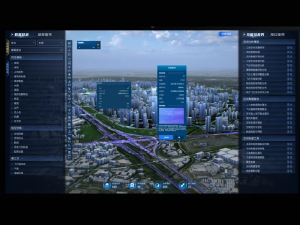
A successful AAM ecosystem requires more than drones and aircraft. It needs a digital management system that provides complete visibility and intelligent control. Our Low-Altitude 3D Intelligent Operations Platform is designed to serve as a “traffic light, controller, and navigation map” for low-altitude operations.
The platform provides full-domain drone situational awareness, intelligent planning, and safety control capabilities. It creates a unified digital environment where operators can understand airspace conditions, monitor drone activities, and optimize operational processes.
By integrating multiple data sources, including remote sensing images, real-scene 3D models, airspace information, IoT sensing data, and business data, the platform enables one-time data collection and multi-party reuse. This reduces repeated infrastructure construction while improving the efficiency of digital asset management.
For cities and organizations developing low-altitude applications, this approach creates a scalable foundation for future expansion.
The Role of 3D Intelligence in Low-Altitude Operations
Three-dimensional understanding is a critical component of modern AAM systems. Traditional two-dimensional maps cannot fully represent complex urban environments, especially when managing flight paths, obstacles, and operational risks.
Through real-scene 3D technology, we create detailed digital representations of physical environments. These models provide accurate spatial information that supports route planning, risk assessment, and operational management.
Our low-altitude operational solutions combine 3D intelligence with air-ground integration. This allows operators to connect aerial activities with ground infrastructure, IoT devices, and business systems.
For example, emergency response teams can use digital environments to understand affected areas and optimize drone deployment. Urban management departments can monitor low-altitude activities while improving coordination between different applications.
By providing deeper environmental awareness, 3D intelligence helps make low-altitude operations more reliable and efficient.
Creating One Map for Complete Low-Altitude Visibility
Managing large-scale low-altitude operations requires a unified view of airspace conditions. Fragmented information can make it difficult for operators to coordinate flights, identify risks, and maintain safety.
Our platform establishes a regional low-altitude “one map” that provides single-screen visibility of key operational elements. It integrates information about airspace, routes, flight status, landing sites, and potential risks into one collaborative management environment.
This unified view improves decision-making by allowing users to monitor multiple activities simultaneously. Operators can better understand current conditions, adjust operational plans, and respond quickly to unexpected situations.
For industries adopting drone-based services, this capability creates a stronger foundation for safe and scalable deployment.
Supporting Multiple Scenarios With Scalable Low-Altitude Solutions
One of the biggest challenges for AAM development is adapting technology to different application requirements. A platform designed for only one scenario may limit long-term value and expansion opportunities.
Our low-altitude platform follows a “one platform for N scenarios” approach. It supports diverse applications, including urban governance, emergency rescue, logistics, modern agriculture, and tourism.
In urban governance, intelligent systems can support infrastructure monitoring and public service management. In emergency rescue, drones can provide rapid information collection and improve response efficiency. In logistics, digital coordination helps optimize aerial delivery networks.
The flexibility of our low-altitude operational solutions allows organizations to expand applications gradually while maintaining a consistent digital foundation.
Building the Future of the Low-Altitude Economy With Digital Innovation
The development of Advanced Air Mobility depends on the integration of aircraft, data, infrastructure, and intelligent management systems. As low-altitude applications continue to expand, organizations need reliable technologies that can support safe and efficient operations.
At Icecypress Technology, we focus on creating advanced 3D and AI technologies that accelerate the growth of the low-altitude economy. Our solutions combine real-scene 3D, intelligent connectivity, and air-ground integration to provide a complete operational framework.
Through our low-altitude platform and low-altitude operational solutions, we help businesses and cities change complex aerial environments into manageable digital spaces. By building stronger connections between physical infrastructure and intelligent systems, we are supporting a future where low-altitude operations become safer, smarter, and more commercially scalable.






