Highway crashes can disrupt traffic long after the initial collision, particularly when investigators need to document vehicle positions, road damage, debris, and other physical evidence. While emergency response and scene clearance remain the priorities, evidence collection must also preserve information for subsequent investigation. Delays in documentation can complicate coordination between investigators and road management teams.
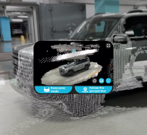
At Icecypress Technology, we develop visual spatial intelligence technologies across 3D reconstruction, UAV mapping, and spatial AI. Our Rusa Rapid 3D Scene Reconstruction System turns supported imagery or video into measurable 3D scene models. By reducing the time needed to produce usable scene information, this approach can help investigation teams work more efficiently when every minute of highway disruption matters.
Why Processing Speed Matters at Highway Accident Scenes
Highway incident management involves several coordinated activities, including emergency treatment, vehicle recovery, evidence collection, traffic control, and roadway inspection. Investigators must record relevant scene details before vehicles or debris are moved and the original conditions change.
Traditional documentation can involve photographs, sketches, and individual measurements. These methods remain valuable, but collecting and organizing numerous measurements can take time, especially at complex collision scenes. Research published in Advances in Engineering Software found that close-range photogrammetry offered time-saving benefits compared with conventional measurement methods in traffic accident investigations.
The processing stage matters because collected images are more useful for detailed spatial analysis when they can be converted into a measurable model promptly. If investigators must wait for lengthy reconstruction before reviewing important details, that delay can affect their workflow and coordination with other personnel.
How 3D Reconstruction Can Support Faster Clearance
The relationship between reconstruction speed and road reopening is practical rather than absolute. Faster processing can reduce the time between capturing a scene and reviewing its spatial details. Investigators can then examine relevant measurements, confirm whether additional documentation is needed, and organize information for subsequent analysis.
A digital model also provides a record that can be revisited after the physical scene has changed. Investigators can inspect vehicle positions, road features, and other captured elements from different viewpoints without relying exclusively on memory or separate photographs.
However, reconstruction is only one part of incident management. Road reopening still depends on scene safety, evidence requirements, damaged vehicle removal, infrastructure conditions, and decisions by the responsible authorities. Faster accident reconstruction software can contribute to a shorter workflow when documentation or review is a genuine bottleneck, but it cannot independently determine when a highway is safe to reopen.
What to Look for in Accident Reconstruction Software
For highway investigations, software selection should focus on processing time, measurement capability, field usability, and the quality of the resulting record. A useful system should turn captured material into information investigators can review and measure without adding unnecessary operational complexity.
Our Rusa system supports rapid reconstruction and minute-level preview generation, allowing teams to check scene coverage before leaving the location. Its full high-precision reconstruction workflow can be completed in up to 40 minutes. Actual processing time depends on the scene and workflow, so agencies should test performance using representative cases.
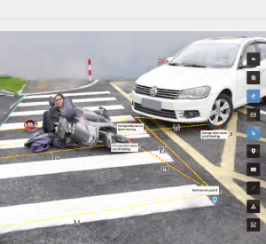
Rusa also supports measurement errors below 2 cm under specified conditions. Available measurement functions include length, area, volume, true distance, horizontal distance, and multi-point measurement. These capabilities help investigators examine spatial relationships, although critical findings should be checked against applicable measurement protocols and evidence standards.
Using AI-Assisted Detection to Focus Investigations
Large crash scenes may contain many objects that are not central to a particular investigation. Finding relevant details among vehicles, roadside equipment, debris, and road damage can add time to scene review.
Rusa provides AI-assisted detection for supported scene elements, including tires, obstacles, traffic signs, and road damage. Users can also hide or filter irrelevant elements to reduce visual clutter and focus on features of interest. The integrated 3D viewer supports zooming, panning, rotation, measurement annotations, custom reports, and multi-format export.
These functions make traffic accident reconstruction tools more useful when several investigators need to review the same scene information. Digital outputs can support communication between field personnel, forensic specialists, and other authorized stakeholders, subject to appropriate evidence handling and documentation procedures.
Integrating Reconstruction into Incident Management
Agencies should evaluate reconstruction technology within their wider incident response process. Clear responsibilities for image capture, model review, evidence retention, and approval help prevent a faster technical workflow from creating confusion elsewhere.
A practical deployment may begin with selected highway incidents. Teams can record capture time, preview availability, final processing time, measurement quality, and the time when relevant lanes reopen. Comparing these records across similar cases can help identify whether reconstruction speed contributes to operational improvements.
When evaluating traffic accident reconstruction tools, agencies should also consider staff training, device compatibility, export formats, data security, and the admissibility requirements applicable to their jurisdiction. A faster model is valuable only when investigators can use its outputs appropriately.
Turning Faster Processing into Practical Results
Processing speed can make highway accident documentation more efficient by shortening the interval between scene capture and measurable digital review. Its contribution to road clearance depends on the wider incident response process, including evidence requirements and authorization to reopen lanes.
At Icecypress Technology, we provide Rusa to support rapid 3D reconstruction, AI-assisted scene review, and precise measurement from supported imagery or video. By evaluating accident reconstruction software against real field conditions and integrating it into established procedures, agencies can identify where faster digital documentation helps reduce delays while maintaining the quality of their investigations.