Large-scale 3D reconstruction requires more than collecting aerial images. Organizations must coordinate data acquisition, process substantial volumes of visual information, maintain spatial consistency, and produce usable digital models across diverse environments. At Icecypress Technology, we develop visual spatial intelligence technologies that connect UAV mapping, photogrammetry, 3D modeling, and spatial AI to address these requirements. Our approach focuses on building workflows that can support extensive geographic coverage while keeping field operations and data processing closely connected.

The Challenge of Scaling 3D Reconstruction Across Large Areas
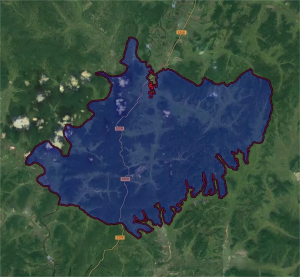
A national-scale reconstruction project presents several operational challenges. Geographic coverage may span dense urban districts, transportation corridors, industrial facilities, and less accessible terrain. Each environment introduces different requirements for flight planning, image capture, data quality, and reconstruction.
Traditional workflows can also create bottlenecks when field teams collect imagery faster than processing teams can turn it into useful outputs. Disconnected tools and inconsistent collection methods may complicate data integration. For organizations planning large mapping programs, an effective AI 3D reconstruction workflow must therefore address both individual scene quality and coordination across the wider project.
Another consideration is operational visibility. Teams need to understand which areas have been captured, whether the available imagery is sufficient, and where additional collection may be necessary. These checks help reduce gaps before datasets enter later processing stages.
Building a Coordinated Workflow with Multi-UAV Collaboration
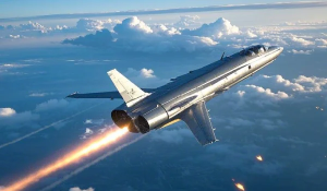
We approach large-area mapping by connecting aerial data acquisition with onboard computing and coordinated operations. Our DroneSwarm Real-Time Onboard Analysis System supports multi-UAV collaborative mapping, real-time 2D/3D reconstruction, target recognition, positioning, tracking, and unified command across drone operations. These capabilities provide a technical foundation for projects where multiple aircraft must contribute spatial information to a broader mapping task.
Using multiple UAVs can help teams organize data collection across separate areas rather than relying exclusively on a single aircraft. Mission planners still need to account for flight conditions, site access, overlap between images, and the accuracy requirements of the intended deliverables. Coordination is particularly important when datasets from different flights must be combined into a consistent spatial representation.
Our spatial intelligence solutions connect these operational considerations with downstream processing. By bringing data acquisition, onboard analysis, and reconstruction into a coordinated workflow, we help organizations manage the transition from raw imagery to structured spatial information. The exact deployment configuration depends on project scope, available equipment, environmental conditions, and the required outputs.
Processing Field Data into Detailed 3D Models
Once imagery has been collected, reconstruction software must identify visual relationships between images and use them to develop a three-dimensional representation. Photogrammetry provides an established foundation for this process, while AI-based techniques can contribute to image interpretation and spatial analysis. The resulting outputs may include textured 3D models, point clouds, or orthomosaics, depending on the workflow and project specifications.
At Icecypress Technology, we develop technologies that connect these stages rather than treating image collection and model generation as unrelated activities. For large projects, processing procedures should account for data organization, coordinate references, quality checks, and the integration of results from different locations.
Our AI 3D reconstruction capabilities are relevant when organizations need to transform visual information into models that can support measurement, inspection, planning, or further analysis. However, the appropriate workflow depends on the source data and required level of detail. Large-area mapping and close-range scene reconstruction serve different purposes, so their capture methods and processing requirements should not be treated as interchangeable.
Using Rusa for Rapid, High-Detail Scene Reconstruction
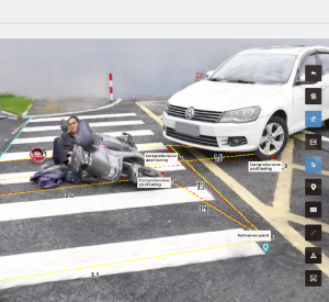
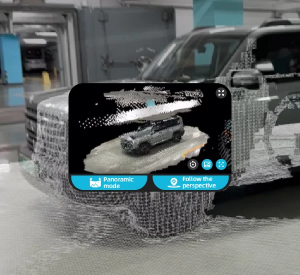
Large geographic programs may also require detailed reconstruction of individual locations. Examples include infrastructure incidents, emergency scenes, engineering sites, and locations where teams need to preserve spatial details for subsequent review. Our Rusa Rapid 3D Scene High-Fidelity Reconstruction System addresses this need by turning supported imagery or video into measurable, high-detail 3D scene models.
Rusa is designed for flexible field deployment, centimeter-level measurement, and rapid reconstruction. The system supports applications including accident investigation, emergency response, forensics, cultural preservation, and engineering.
For a national-scale program, Rusa can be considered for suitable site-level tasks within a broader spatial data workflow. It is important to distinguish this role from city-scale or regional modeling: a rapid reconstruction of an individual scene does not, by itself, replace the surveying, data integration, and quality-control processes required for a geographically extensive model.
Maintaining Quality Across the Project Lifecycle
A reconstruction program should evaluate data quality throughout collection, processing, and delivery. Teams need to check image coverage, identify areas with insufficient visual information, and review whether reconstructed outputs meet the intended requirements. Coordinate consistency and documented processing procedures are also important when multiple teams contribute to a shared geographic dataset.
Our spatial intelligence solutions support workflows that connect capture, reconstruction, and spatial analysis. For B2B customers, the value lies not only in producing detailed models but also in making spatial information practical for existing operational processes. Deliverables should be selected according to their intended use, whether that involves geographic visualization, infrastructure review, or detailed scene measurement.
Project reporting should distinguish verified results from planned capabilities. Accuracy, processing speed, and coverage depend on factors such as capture conditions, source data, and project configuration. Establishing acceptance criteria at the outset helps stakeholders assess results against the actual requirements rather than relying on general performance claims.
Extending National Mapping into Practical Spatial Intelligence
A large reconstruction initiative creates greater value when its outputs can support real operational decisions. Detailed spatial models may provide a reference for infrastructure management, emergency planning, inspection, and geographic information workflows. AI-based analysis can add context to reconstructed environments, helping users identify relevant objects and interpret spatial relationships where the deployed system supports those functions.
At Icecypress Technology, we bring together UAV mapping, AI 3D reconstruction, and spatial analysis technologies to help organizations build connected geospatial workflows. Our spatial intelligence solutions address different requirements, from collaborative aerial data acquisition with DroneSwarm to high-detail scene modeling with Rusa. The appropriate combination depends on the project’s geographic scale, accuracy requirements, operational constraints, and intended deliverables.
For national-scale projects, successful delivery depends on coordinated collection, suitable processing methods, consistent quality checks, and clear output requirements. By connecting these elements, we help professional teams turn visual data into structured spatial information that can support mapping, infrastructure, and emergency-response applications.