
In road construction, concealed works are often the aspects that require the most rigorous management and are most prone to becoming difficult points for review.
After construction is completed, many critical construction processes are covered by subsequent structures.
Traditional management methods primarily rely on paper records, on-site photos, and manual measurement. While they can form basic documentation, there are still many difficulties in process restoration, measurement review, result verification, and subsequent traceability.
Whether the on-site records are authentic and complete, whether the basis for engineering quantities is consistent, whether reports are verifiable, and whether subsequent audits can be quickly traced—these issues are directly related to the transparency of project management and the credibility of outcomes.
Respond to engineering management pain points
Addressing this need, ICE CYPRESS introduces the Concealed Works Video Measurement System. Targeting scenarios of concealed works acceptance, measurement, and archiving, it builds integrated capabilities from on-site collection, 3D measurement, result reporting, ledger management to audit traceability, helping your projects establish a unified, credible, and reviewable data foundation.

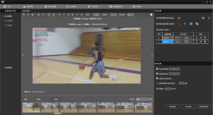
The system centers on video collection and real-scene 3D measurement. On-site personnel can complete work video collection via mobile phones, with videos, photos, and key information uploaded synchronously, forming complete documentation.
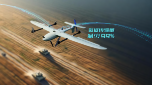
A standard scale establishes the dimensional reference, ensuring the reliability of subsequent measurement results. In complex or large-scale scenarios, it can also be extended to drone collection, improving on-site data acquisition efficiency.
After data upload, the platform backend automatically retrieves the videos and performs algorithmic modeling analysis, quickly generating a measurable real-scene 3D model, achieving a 1:1 restoration of the construction site.
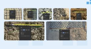
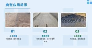
The system supports measurement of various core data types such as area, volume, and distance, providing a digital measurement basis for typical concealed works scenarios like geogrids, old road defects, and geocells.
From on-site collection to credible reports
The key to digital management of concealed works is not just data collection, but also transforming the data into reviewable, retrievable, and traceable outcomes.
In the result output phase, the system can automatically generate a unique measurement report based on on-site information and measurement results.
The report content can cover key information such as project name, section, time, construction area, measured area, measurement diagrams, and on-site watermarked photos. Through unique identification codes, digital watermarks, and signature mechanisms, it ensures the results are authentic, unique, and verifiable.
The platform also provides capabilities such as data ledgers, report queries, authenticity verification, report duplication checks, and audit trails. Project managers can perform unified management and statistics by dimensions like project, section, time, type, and area. They can also quickly locate required reports, verify report authenticity and uniqueness, reducing duplicate calculations and post-event evidence collection costs.

Through this closed loop, concealed works documentation is no longer just scattered photos and forms, but is consolidated into structured, queryable, and verifiable project-level digital assets.
Project verification supports large-scale application
In on-site project verification, the system has completed process closure and accuracy verification focusing on collection efficiency, measurement accuracy, acceptance timeliness, and traceability capabilities. Verified by extensive data, the system’s average error remains stable at 2-3 centimeters, achieving centimeter-level accuracy.
Currently, the Concealed Works Video Measurement System has undergone application verification based on the G3 Beijing-Taipei Expressway Bengbu to Lukou Hub Section Reconstruction and Expansion Project, covering 6 sections, cumulatively processing over 150 construction area scenarios, with a total processed area exceeding 500,000 square meters.
In the future, the system can also be extended and integrated with capabilities such as drone inspection and AI recognition, unifying the management of multi-source data including videos, models, and reports, gradually forming a project-level digital archive system to support regionalized and large-scale application.
Transforming concealed works management from “documentation” to “visualizable, measurable, and traceable” not only changes the way information is retained but also provides clearer and more credible digital bases for acceptance, measurement, and traceability.