

For many, the first thoughts that come to mind regarding the low-altitude economy are air taxis, flying cars, or even dense aerial traffic weaving through future cities.
However, seeing only this layer reveals just the most conspicuous aspect of the low-altitude economy.
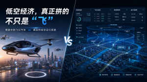
As we enter 2026, the low-altitude economy is no longer just a story about aircraft. Following the surge in attention over the past two years, the industry is moving into a more pragmatic second half. The real competition today is not just about whose aircraft is more advanced, but about who can transform the low-altitude airspace into a computable, schedulable, and manageable infrastructure.
The Low-Altitude Economy: More Than Just “Flight”
In essence, the low-altitude economy is not a single equipment industry, but a new production system centered around low-altitude airspace.
It utilizes manned aircraft, drones, eVTOLs, and general aviation equipment as carriers, supported by airspace management, flight services, communication, navigation, surveillance, spatial data, regulatory systems, and scenario operations. Its ultimate goal is to transform the originally fragmented, low-frequency, and difficult-to-scale low-altitude airspace into a new type of spatial resource that continuously creates value.
Therefore, what is truly important for the low-altitude economy is not just the equipment flying in the sky, but the ground-based capability system that ensures the stable operation of this entire framework.
It’s A Decade in the Making
Many perceive the low-altitude economy as a trend that suddenly emerged in 2024. In reality, it is more like a concentrated release after over a decade of accumulation.
One thread is the continuous advancement of low-altitude airspace management reform, gradually bringing airspace opening and governance into the purview of institutional development.
The other thread is the maturing of China’s drone industry, which has validated the practical value of low-altitude space in scenarios such as agricultural plant protection, power line inspection, surveying and modeling, and emergency response.
Unlike some countries that extended from traditional aviation systems, China’s low-altitude economy largely grew from “working drones” that get the job done. Precisely because of this, China’s low-altitude economy gained momentum not starting with passenger flight, but with real needs, industrial applications, and scenario implementation.
Landing in Mission-Based Scenarios
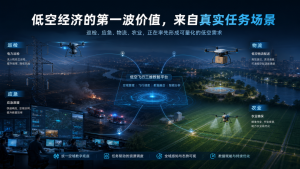
From a practical demand perspective, the most stable and sustainable revenue sources for the low-altitude economy in the coming years will still come from B2B and government (G2B) mission-based scenarios.
Whether it’s power line inspection, urban governance, emergency response, campus logistics, modern agriculture, or low-altitude cultural tourism, these scenarios share common characteristics: their value is easily quantifiable, they involve high costs for human labor replacement, and they have clear needs for high-frequency, stable, and continuous operational capability.
In contrast, the most eye-catching passenger eVTOLs will, for a considerable time, primarily play roles in demonstration applications and industry leadership. Factors like airworthiness certification, takeoff/landing infrastructure, safety redundancy, and operational costs determine that they will find it difficult to become the mainstream form of mass commuting in the short term.
This means the winners in the first phase of the low-altitude economy may not be the best aircraft manufacturers, but rather capability-driven players who can truly integrate scenarios, rules, flight services, data, and equipment into a stable system.
Why “Compute” the Sky?
Because the low-altitude sky is not a naturally blank canvas. Buildings, bridges, power lines, communication towers, mountains, rivers, weather changes, population density, and no-fly/restricted zones all directly impact flight activities.
Whether aircraft can operate safely, routes can be planned efficiently, missions can be executed continuously, and oversight can be enforced in real-time fundamentally depends on the refined understanding and systematic management of the low-altitude environment.
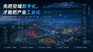
Therefore, low-altitude airspace must first be digitalized before the industry can be industrialized.
Capabilities like high-precision remote sensing imagery, real-scene 3D modeling, obstacle identification, airspace grid division, 3D route planning, flight activity monitoring, video and spatial scene fusion, risk warning, and safety assessment—which may not sound particularly “aviation-centric”—are precisely what determine whether the low-altitude economy can move from pilot projects to scaled implementation.
The real trump card of the low-altitude economy is not “flying” the sky, but “computing” it.
Platform Capability is Becoming the Key Differentiator
Today’s low-altitude economy is transitioning from being device-driven to system-driven.
What the industry truly needs is not just point solutions, but a low-altitude digital foundation capable of connecting airspace, data, regulation, and application scenarios. This foundation must address pre-flight planning, in-flight monitoring, and post-flight review, optimization, and continuous operations.
In other words, the industry’s competitive focus is shifting from “having aircraft” to “having platform capabilities.”
Those who can clearly see, accurately compute, effectively manage, and productively utilize the low-altitude airspace will have a better chance of truly entering the long-term value chain of the low-altitude economy.
ICE CYPRESS: Building the Digital Foundation for Low-Altitude Operations
Addressing the core pain points of “invisible, unreachable, unmanageable” in low-altitude operations, ICE CYPRESS has developed the 3D Digital Intelligence Platform for Low-Altitude Flight.
The platform relies on a comprehensive spatial data system, integrating multi-source dynamic data such as real-scene 3D models, BIM, GIS, IoT, weather, airspace rules, and traffic flow to construct a four-dimensional spatial situation map. This transforms complex physical airspace into a digital model that is perceivable, analyzable, and schedulable.
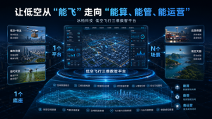
In terms of capability, the platform addresses not just “seeing,” but simultaneously focuses on three levels: “computing, managing, and operating.” Covering the entire workflow of pre-flight, in-flight, and post-flight, the platform supports intelligent route planning, flight visual domain analysis, obstacle collision risk assessment, real-time 3D monitoring, traffic flow prediction, conflict warning, as well as data review and scenario optimization, promoting low-altitude flight operations to evolve from isolated pilots to systematic operations.
Simultaneously, the platform adopts a “1 foundational system + 1 platform + N application scenarios” development approach. Based on the comprehensive spatial data system and centered on the 3D Digital Intelligence Platform for Low-Altitude Flight, it delivers capabilities for scenarios such as low-altitude logistics, urban governance, smart emergency response, modern agriculture, and low-altitude cultural tourism, helping to transform low-altitude space into a productive force that sustainably creates value.
The Endgame: Flying as a System, Not Just Higher
As the industry enters its second half, what truly matters is no longer the dazzling display of individual devices, but who can truly integrate low-altitude airspace, spatial data, flight regulation, and industrial scenarios.
Making the sky perceivable, computable, schedulable, and operable is not only the necessary path for the low-altitude economy to mature, but also the ongoing direction for ICE CYPRESS’s 3D Digital Intelligence Platform for Low-Altitude Flight.






