
Recently, Kenyan legislator Stephen Ntutu, accompanied by Ronald from Leyian Transsnet Co., Ltd., visited Ice Cypress Technology and held productive exchanges and negotiations. The two parties focused on fields such as dynamic monitoring of animal migration, digital agricultural applications, and land surveying and mapping, and discussed in-depth cooperation paths based on low-altitude intelligent equipment and digital technologies, so as to jointly promote the high-quality development of ecological protection and modernization in Kenya.

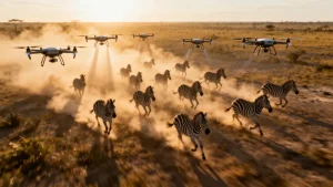
In the field of animal conservation, Ice Cypress Technology demonstrated the independently developed DroneSwarm UAV Swarm Real-time Online Analysis System. This system integrates core capabilities including on-board real-time 2D/3D reconstruction, efficient target recognition, dynamic tracking and precise positioning. It supports continuous dynamic monitoring of animal migration routes and scale, can cover large areas and enables long-term stable operation.
This solution provides comprehensive and accurate data support for government organizations and scientific research institutions, helping Kenya scientifically formulate conservation strategies and ensure the sustainable development of the ecological environment.
Digital agriculture is a key issue of high concern for the Kenyan side. Ice Cypress Technology integrates multi-source low-altitude sensor data, combined with advanced 3D reconstruction technology and artificial intelligence perception capabilities, to build a full-link digital agricultural solution from farmland data collection to intelligent analysis.
This solution can monitor crop growth conditions, pests and diseases, and soil environment in real time, improve the precision and intelligence level of agricultural production, assist Kenya’s agricultural modernization transformation, and ensure food security and sustainable development.
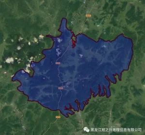
In the field of land surveying and mapping, Ice Cypress Technology relies on independently controllable rapid 3D large-scale scene modeling technology to provide high-precision urban-level land surveying and mapping data support for Kenya. This technology is widely applicable to important fields such as infrastructure construction, urban planning, resource management and disaster prevention, helping Kenya improve the informatized management capacity of land space and accelerate the national modernization process.

Both parties agreed to give full play to their respective advantages, deepen cooperation in the application of low-altitude intelligent equipment and digital technologies, and continuously improve the digital level of ecological protection, smart agriculture and land surveying and mapping. Ice Cypress Technology will continue to promote the innovation of core technologies and, combined with local actual needs, help Kenya move steadily along the road of ecological environmental protection and sustainable development.