
For this reserve data processing, Mirauge3D was used to perform aerial triangulation and produce digital orthophoto maps, effectively solving the problem of aerial triangulation segmentation under conditions of massive data volume, weak texture, and sparse ground control points. The entire aerial triangulation computation was completed in a single project submission, and the orthomosaic module was used to generate digital orthophoto maps, significantly improving overall production efficiency.
Mirauge3D, Orthophoto Map, Efficient and Robust Aerial Triangulation
I. Project Overview
1. Project Background
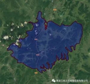
The Heilongjiang Zhongyangzhan Black-Billed Capercaillie National Nature Reserve is located in Nenjiang County, Heihe City, Heilongjiang Province, at the southern foot of the Yilehuli Mountains—where the Greater and Lesser Khingan Ranges meet—and on the northern edge of the Songnen Plain. It borders Aihui District of Heihe City to the east, Wodu River Forest Farm to the south, Gala Mountain Forest Farm to the north, and faces across the river the Morin Dawa Daur Autonomous Banner and Oroqen Autonomous Banner of Inner Mongolia Autonomous Region to the west. Its geographic coordinates range from 125°44′57″E to 126°13′31″E longitude and 50°38′23″N to 50°48′10″N latitude. The reserve is approximately 28 km long from north to south, 24 km wide from east to west, with a perimeter of about 116 km and a total area of approximately 467 km², including a core zone of about 202.71 km², a buffer zone of about 101.94 km², and an experimental zone of about 162.78 km².
The Heilongjiang Zhongyangzhan Black-Billed Capercaillie National Nature Reserve is a comprehensive wildlife-type nature reserve integrating biodiversity conservation, scientific research, education and publicity, ecotourism, and sustainable utilization, primarily established to protect endangered species such as the Black-Billed Capercaillie and their habitats. It was approved by the Heilongjiang Provincial Government as a provincial-level nature reserve in December 2006 and upgraded to national status by approval of the State Council in December 2013.
Since its establishment, with strong attention and support from higher authorities, the reserve’s management system and infrastructure have been gradually improved. Through the continuous efforts of all staff, substantial work has been carried out in resource protection and baseline surveys, promoting the development of wildlife conservation.
To further enhance the scientific and standardized management and construction of the Zhongyangzhan Reserve, more effectively protect endangered species like the Black-Billed Capercaillie and the biodiversity of their habitats, and meet the requirements of sustainable development strategy, it was decided—based on actual needs—to use the Feima F200 intelligent UAV mapping system to acquire high-resolution aerial imagery at a scale of 1:2000 in the CGCS2000 coordinate system, and to produce digital orthophoto maps. These data will be used to carry out systematic scientific monitoring, develop robust monitoring plans, better protect regional natural resources, improve the effectiveness of scientific monitoring and conservation management, and achieve sustainable development of the nature reserve.
Boundary of the Heilongjiang Zhongyangzhan Black-Billed Capercaillie National Nature Reserve
2. Necessity of Conducting Scientific Monitoring Using Digital Orthophoto Maps
2.1 Important Geographic Location and Rich Natural Resources
Located in northwestern Heilongjiang, the Zhongyangzhan Reserve lies in the transitional zone between the Songnen Plain and the Greater and Lesser Khingan Mountains, featuring a semi-hilly terrain that slopes downward from north to south and east to west. Its geographical environment and phenology exhibit distinct characteristics. This unique location provides ideal habitats for wildlife and forest ecosystems dominated by rare tree species, making it an optimal site for monitoring wild flora and fauna and ecological environments—thus rendering scientific monitoring here both necessary and highly suitable.
2.2 Need for Biodiversity Conservation and Research
The purpose of scientific monitoring is to track changes in natural resources and provide scientific basis for their rational conservation and utilization; it is an indispensable component of natural resource protection.
2.3 Need for Ecological Database Construction in the Reserve
With the large-scale implementation of wildlife and ecological conservation in China, scientific monitoring in this area not only fills critical gaps in understanding the dynamic patterns of wildlife resources across vast unmonitored regions of the country but also supplements and refines existing knowledge on conservation strategies, thereby making due contributions to global natural resource protection.
2.4 Need for Normal Operation of Reserve Activities
Systematic scientific monitoring helps enhance staff competence and creates suitable working, learning, and living environments, thereby boosting staff motivation, stabilizing the workforce, enabling knowledge sharing, strengthening staff pride and sense of honor, and improving work efficiency. Showcasing these achievements also promotes external communication and publicity, delivering significant social, economic, and ecological benefits.
2.5 Need to Fulfill International Conventions and Advance Biodiversity Conservation
With the implementation of China’s Belt and Road Initiative, China’s global role and influence are increasingly prominent, diplomatic activities are growing more frequent, and international attention toward China’s ecological conservation efforts is rising. Scientific monitoring in the reserve will become part of international exchanges, thereby promoting biodiversity conservation.
2.6 Concrete Implementation of the “National Wildlife Protection and Nature Reserve Construction Project”
To meet the needs of China’s national economic and ecological development, the State Forestry Administration launched six major forestry projects, one of which is the “National Wildlife Protection and Nature Reserve Construction Project.” Scientific monitoring in nature reserves is a key component of this initiative, and the implementation of monitoring activities in the Zhongyangzhan Reserve represents a concrete step in executing this national program.
II. Project Implementation
Project implementation was divided into three phases: data acquisition, data processing, and production of digital orthophoto maps and digital surface models.
1. Project Organization
1.1 Personnel Arrangement
Three technical personnel were assigned to complete field ground control point surveying, UAV flight operations, and indoor data processing.
1.2 Intelligent Aerial Survey System
Due to the reserve’s large area and complex terrain, CORS network signals were poor, making ground control point deployment difficult. The Feima F200 intelligent UAV mapping system is equipped with a dual-frequency differential GPS positioning system; through PPK post-processing, it acquires centimeter-level POS data, significantly reducing the number of required control points, lowering personnel safety risks, and improving operational efficiency. We used one Feima F200 UAV equipped with a 42-megapixel ortho module to capture high-resolution aerial imagery, combined with sparse ground control points, completing full coverage of the reserve through multiple takeoff and landing sorties.
1.3 Software and Hardware for Data Production
Data processing was performed using Feima UAV Manager—“Full-Product Image Workstation”—in conjunction with the Mirauge3D fully automatic intelligent image modeling system for indoor image processing to produce high-resolution digital orthophoto maps and digital surface models. Four workstations were used for indoor data processing.
Feima UAV Manager
Hardware Configuration Table for Mirauge3D Fully Automatic Intelligent Image Modeling System
1.4 Other Operational Equipment
Operational vehicles, RTK receivers, laptop workstations, etc.
1.5 Data Deliverables
2. Data Acquisition
2.1 Ground Control Point Surveying
After on-site reconnaissance and considering the reserve’s terrain and accessibility, ground control points were pre-planned in Google Earth software. Physical targets were then deployed on-site prior to UAV flights, and RTK was used to measure the precise coordinates of each control point.
Ground Control Point Location Map
2.2 Flight Path Planning
The reserve is predominantly mountainous, with elevations ranging from approximately 300 m to 600 m. The “Smart Route” module of Feima UAV Manager was used for flight planning: the reserve’s KML boundary was directly imported into Smart Route, which automatically segmented and managed the mission area to ensure seamless edge matching in post-processing. Based on 1:2000 scale accuracy requirements and terrain conditions, a ground sampling distance (GSD) of 14 cm was designed, with 75% forward overlap and 70% side overlap. After block generation, the route generation function automatically created flight paths at a relative flying altitude of approximately 1,086 meters.
Flight Path Planning
2.3 UAV Flight Operations
The Feima UAV features a modular design for rapid assembly, hand-launched automatic takeoff, and real-time monitoring during flight of key parameters including aircraft attitude, position, altitude, airspeed, and remaining battery power. Landing is achieved via a disposable parachute—no folding or maintenance required—with automatic wind direction and speed calculation for fully autonomous pinpoint parachute descent. Field flight operations lasted a total of 22 days, with 96 sorties conducted and 83,504 aerial images acquired.
2.4 Data Quality Inspection
After UAV flights, the “Smart Inspection” module of Feima UAV Manager was used for rapid on-site quality assessment. After data import, users clicked “Process” to execute quality inspection and then reviewed the inspection results.
2.5 Perform Quality Inspection
3. Data Processing
3.1 Differential Solution
The “Smart Processing” module of Feima UAV Manager was used for UAV data preprocessing. Base station and onboard GNSS data were first converted to RINEX standard format, then imported into Smart Processing to compute centimeter-level POS data.
RT27 Format Conversion
GPS Solution
3.2 Image Processing
The “Smart Processing” module was used to correct lens distortion and perform color balancing. Using Feima’s proprietary grid-based distortion model algorithm, camera distortion was simulated block-by-block, accurately quantifying distortion from non-standard cameras to achieve high-precision mapping.
Distortion Correction
3.3 Product Generation
As the reserve is located in a forested region with complex terrain, large elevation differences, and dense vegetation, field UAV photogrammetry and ground control point deployment were extremely challenging. Additionally, springtime flights coincided with rapid vegetation growth, resulting in imagery with significant texture and color inconsistencies. These factors made indoor data processing difficult and placed high demands on both software and personnel—conditions that Mirauge3D is specifically designed to handle.
Mirauge3D is a professional intelligent image modeling system capable of handling both 2D and 3D data processing. It provides robust support for datasets characterized by large volume, weak texture, sparse control points, and varying flight altitudes across multiple sorties. For this reserve project, Mirauge3D was used for aerial triangulation and digital orthophoto production, perfectly resolving the segmentation issue under conditions of massive data, weak texture, and sparse control points. The entire aerial triangulation was completed in a single project submission, and the orthomosaic module was used to generate digital orthophoto maps, greatly enhancing overall production efficiency.
POS Distribution of Aerial Photos
POS Distribution of Aerial Photos
Optimized Seamlines
4. Data Deliverables
Digital Orthophoto Map
Digital Surface Model
III. Applications of Digital Orthophoto Maps in Scientific Monitoring
1. Ecosystem Large-Scale Plot Monitoring
Using the reserve’s digital orthophoto maps, vegetation conditions were analyzed to select areas with minimal human disturbance, relatively intact natural succession, convenient access, and good observability. Monitoring includes forest atmospheric environment, routine meteorology and microclimate, soil physicochemical properties, forest hydrology and phytochemistry, community composition and structure, ecosystem vitality, resilience, and health. Digital orthophotos also enable collection of compartment and sub-compartment data, providing detailed tree-level information for targeted forest inventory and planning. Researchers can automatically generate compartment boundaries from orthophotos, achieving accuracy sufficient for practical forestry operations, thus significantly reducing field survey workload and improving efficiency.
Boundary of Large-Scale Monitoring Plot
2. Infrared Camera Transect Monitoring
Using digital orthophoto maps, infrared camera placement was optimized based on the reserve’s spatial layout, topography, and wildlife movement patterns. While UAV monitoring was conducted, infrared cameras supplemented observations of behavioral patterns, population dynamics, and ecology of species like the Black-Billed Capercaillie. Every deployed camera captured valuable footage of wildlife, including brown bears, lynx, moose, foxes, wolves, snow hares, grass hares, badgers, raccoon dogs, and various bird species.
Infrared Camera Deployment Map for Monitoring Plots
Infrared Camera at Monitoring Plot – SY_00008 – Black-Billed Capercaillie
Infrared Camera at Monitoring Plot – SY_00017 – Brown Bear
3. Functional Zoning of the Reserve
Nature reserves are functionally zoned into core, buffer, and experimental areas. The core zone contains well-preserved natural ecosystems and concentrated distributions of rare and endangered species; only scientific research is permitted in the buffer zone; tourism activities may be conducted in the experimental zone.
4. Ecological Environment Monitoring
During calm mornings from April to November each year, UAVs conduct fully autonomous, georeferenced flights over the entire reserve to acquire digital orthophoto maps at different times. Comparative analysis of these images is used to monitor changes in forests, wetlands, land cover, and other features within the reserve.
Comparative Maps of the Reserve at Different Time Periods
5. Wild Plant Database Construction
Vector patches of different land cover types were extracted from digital orthophoto maps and integrated with existing data to build a wild plant database for monitoring vegetation coverage and tracking ecological restoration progress. This supports effective ecosystem protection, enhances climate regulation, soil and water conservation, and water retention functions, reduces natural disasters, and provides a direct protective barrier for surrounding agricultural and pastoral production.
6. Wildlife Movement Trajectory Analysis
By fitting wildlife with trackers, data on movement trajectories, start times, duration, speed, dwell time, distance traveled within zones, frequency of zone entries/exits, latency before first entry, and social interactions among individuals are recorded, yielding real-time insights into behavioral patterns (e.g., feeding, sleeping, moving, chasing). These data are categorized and overlaid onto digital orthophoto maps to generate wildlife activity reports, visualizing spatial behaviors and assisting reserve staff in identifying abnormal behaviors—enabling timely intervention and optimal rescue response.
7. Wildlife Database Construction
Leveraging the geometric and spectral characteristics of the reserve’s digital orthophoto maps, various monitoring data are integrated. Through long-term accumulation, the following databases are progressively established and refined: baseline wildlife resource database, seasonal population dynamics database, life history database, and kinship-based population tracking database.
This enables comprehensive and accurate understanding of wildlife life histories, population and community dynamics, carrying capacity during breeding and wintering seasons, interannual population fluctuations and their causes, seasonal and interannual climate patterns, and standardized protocols for wildlife rescue—providing reliable, detailed foundations for scientifically integrated wildlife conservation strategies.
IV. Significance
The scientific monitoring conducted using digital orthophoto maps generated by the Feima intelligent UAV system and Mirauge3D intelligent modeling system received strong support from provincial government departments. Heilongjiang TV’s “News Night Navigation” program produced a dedicated feature report, and the approach was widely promoted across the province. The reserve’s biodiversity conservation efforts have yielded substantial results, laying a solid foundation for future protection and research. Equipped with modules for video transmission, infrared imaging, LiDAR, and more, the Feima intelligent UAV system—combined with advanced technologies—can greatly assist daily monitoring tasks including forest fire prevention, forest inventory, patrol, vegetation coverage assessment, pest and disease monitoring, tracking of disturbed land area changes, soil and water conservation evaluation, ecosystem health analysis, biomass estimation, meteorological, hydrological, and soil monitoring, wildlife tracking, anti-poaching/anti-illegal harvesting aerial patrols, and reserve planning and construction.
Partial content of this article was provided by the Heilongjiang Zhongyangzhan Black-Billed Capercaillie National Nature Reserve.